Sunday June 20th. Niyapull (1,070 meters – 3,510 feet) to Naya Thanti (2,220 meters – 7,283 feet)
Because of the limited time that I had allocated for my trek, I could not do the complete 20-day Annapurna Circuit. Instead I decided to hike up to the Hindu temple at Muktinath and then return by a slightly different route. The trek follows a path through the mountains that connects the several villages in the region. The first day of hiking begins at the Seti Khola or White River and leads through the green mountains and fields, terraced to allow for rice farming.


The hiking was manageable until just after lunch which is when the real climbing began, in this case in the form of 3,767 steps (I’m relying on someone else’s count). As I mentioned previously, I chose Nirmal as my guide for the trek. During this climb it became harder for me to answer his frequent questions “Tiksa?”, “Are you okay?”, with “Tiksa.”, “I’m okay”. Mid way up, it also started to rain which meant that the stone steps had become a beautiful (and slippery) rock waterfall … one that we were climbing. After a much-needed rest at Ulleri (1,960 meters - 6,430 feet) we climbed the rest of the way to Naya Thanti. There we spent the night at a bare bones guest house where we were hosted by Govin. Since we were the only two trekkers in the village we spent a lot of the evening with him eating dried sheep meat (which was delicious) and trying to dry off in front of the wood stove.
 With virtually no reliable refrigeration in the region, drying meat, which ends up like jerky, is one way of preserving it. Every guest house seemed to have a different variety and flavor, but all of it tasted great when softened a little in a hot pan with some oil, tomatoes, peppers, onions and spices.
  After my hot bucket rinse, we sat down to eat. Govin said he would be happy to kill a chicken for me if I really wanted chicken fried rice, so I opted for the macaroni instead. Our day started humid and warm and ended wet and chilly. That evening it continued to rain … hard. Perhaps the tin roof exaggerated the rainfall amount, but as I dozed off beneath a heavy, well-used quilt, I couldn’t help but wonder if landslides were common in this area.
Govin told me the next morning that not far from the infamous steps a landslide had occurred a few years ago killing several dozen people. I’m glad I didn’t know that when I was trying to fall asleep.


We were walking beneath this 8,167 meter (26,795 foot) mountain during much of the previous day but it failed to make even one appearance. We had nice views for about 10 minutes before the clouds locked it away from site.
 Today was a wild day for changes in scenery. In terms of U.S. references, it was like walking from the green Cascade mountains of Washington, to Yellowstone (dry and pine covered), to Arizona (red rock desert), to West Texas (almost no vegetation), all within an 11 hour hike. I have never seen such rapid contrasts.
The one constant was the river which, even in the driest regions, continues to flow because its source lies in the glaciers of the Annapurna Mountains. This was our longest hiking day. Highlights included a visit to the small Tibetan refugee village of Chhairo. The village was beautiful with orchards, cotton woods and gardens.


For hours we continued our walk along a barren landscape being pushed from behind by the strong dry winds. At one point another muddy river emerged from the hills.
 We were going to have to cross this one by foot, except for the excellent timing of a truck which gave us a lift over the flooded trail. Toward the end of the day, Kagbeni finally came into sight. Protected in a narrow valley and surrounded by golden wheat fields, it looks like Shangri La.


 We spent the night at an awesome guest house where Nirmal and I were the entertainment. Ama, who ran the guest house (and who opined that Nirmal and I were “same-same” in the trouble making category) decided that Nirmal should marry her daughter and I should marry one of her field workers.
 Everyone seemed to enjoy the joke, except for the poor field worker who looked decidedly unhappy at the thought of marrying me.

Ama insisted that the following night we would have a “big party”, “big disco”. It was another great evening.


Along the trek we were periodically approached by kids asking for “sweets”, or in one case, a “skupen” (school pen). I brought some lollypops and other treats with me for that purpose. By now, the only sweets I had left to offer were red Twizzlers, which although they taste great to me, they weren’t something that Nirmal thought anyone (even curious kids) would like. In Kalapani, we found out. I marketed the Twizzlers as a nifty, edible straw. These boys cracked me up as they tried to figure it out. In the end, I think they got mixed reviews.
 As we again approached the narrow section of the Kali Gandaki we noticed that the water was a chocolate brown which we speculated meant that there had been a large landslide somewhere upstream. It continued that color all day. Along the way, we passed more Indian holy men
 and passed two guys hiking the trail in sandals each with about 90 kilos (198 lbs) on their backs.
 It made me appreciate a little more every job I’ve had in my life. More waterfalls, more kids multiplying like the Tibetan venders at the sight of my red licorice, and more sore feet (I counted five blisters at the end of this day) and we arrived at Tatopani at about 6:30 p.m.


After a fast breakfast we did a quick hike up to Poon Hill for the panorama. Although the clouds didn’t stay away long, we did get a chance to see most of the big peaks, including previously mentioned Dhaulagiri, Machhapuchhapuri, and Nilgiri and also Annapurna I (10th highest in the world at 8,091 meters – 26,545 feet) and Annapurna South (7,219 meters – 23,684 feet). Success!


After descending back down to Ghorepani, we began our hike to Ghandruk. We were warned that the leeches were especially bad on this portion of the trek. By the end of the day, I had pulled at least 20 off of my clothes and boots, only two of which managed to attach themselves to my ankles. Much of the hike was in fog and over the tops of some mountains, although they weren’t overly steep. We did pass through some beautiful Rhododendron forests full of ferns, flowers and other plants and crossed a lot of small streams.


 We also ran into this Gurung man (one of the local castes). He told us he hadn’t worn shoes since he was a child. When I asked to take his picture, he proudly repositioned his pack and gave me his best stoic look. Very handsome.
 It started raining as we approached Ghandruk and we were soaked by the time we arrived. Fortunately, the guest house was nice. While waiting for dinner we were entertained by a young man who was a self-taught flutist. He sounded great, but what surprised me most, was his rendition of “How Great thou Art.” I asked him the name of the song and he said he simply called it Holy Song. How this Swedish folk melody got transferred to the mountains of Nepal to be picked up by an unschooled musician is a story I would really like to know. This was a hard night because my lips, which had been sun/wind burned while I was on the upper reaches of the trek, had finally blistered.


 To be invited into their one room home for dinner was one of the sweetest experiences of my visit to Nepal. I was overwhelmed by their kindness, trust and generosity. This was the beautiful, unexpected finish to a difficult, fantastic adventure, one for which I will be forever grateful and will, hopefully, never forget.


Because of the limited time that I had allocated for my trek, I could not do the complete 20-day Annapurna Circuit. Instead I decided to hike up to the Hindu temple at Muktinath and then return by a slightly different route. The trek follows a path through the mountains that connects the several villages in the region. The first day of hiking begins at the Seti Khola or White River and leads through the green mountains and fields, terraced to allow for rice farming.


Each hour the terraces became steeper and steeper. Sometimes following streams, we were frequently crossing waterfalls and suspension bridges.

Much of the trail was on stone steps that had been set into the hills over the years.
 |
This black dog was happy to follow us for half of the day. |
 |
Our brightly-painted lunch site at Hile |


 |
The bright flash makes this room seem a lot cheerier than it felt. |
Monday June 21st. Naya Thanti (2,220 meters - 7,283 feet) to Ghorepani (2,860 meters - 9,383 feet) to Tatopani (1,190 meters – 3,904 feet) to Dana (1,440 meters - 4,724 feet)
The next morning we pushed on to Ghorepani where we hoped to have our first big views of the Himalayas. This is what we saw.

No matter. As Nirmal and I frequently told ourselves, “We’re walkers” which meant that we were in it for the journey, so off we went, this time down, way down. This portion of the trail was even better than the first day. We had great views and ran into a lot of nice people (and animals).


The views were typical of the region as were the buildings. In this area it is common to have frequent rest points with water basins to catch the water flowing from either a spigot or directly from a spring. The scenery reminds me somewhat of the Elf Kingdom in Lord of the Rings.


 |
| Clever stone steps leading up to a house. |
Eventually we made it to Tatopani, the site of a natural hot spring. After a welcomed soak in the very hot pool, we started shadowing the wild, muddy Kali Gandaki River (Black Gandaki River). From here the trek actually follows a road. The road was built about 7 years ago and does provide a limited means of access to the upper mountain region.

 |
| Curious plants growning along the road sides. Possible explanation for very chilled out goats? |
Most of the way, however, it is a muddy, potholed trail, subject to falling rocks, landslides and erosion. The most frequent travelers on the road seem to be the Indian tourists loaded into small mini-busses trying to reach the holy site of Muktinath. Watching the cramped pilgrims crawl along the bone-jarring trail left me thinking that no one could doubt their devotion. It also left me feeling grateful that I was walking. At some point early on our trek Nirmal taught me a few vital words when village trekking in Nepal … “Namaste ama!”, “Namaste baboo!”, “Namaste bohemie!”, which mean respectively, “Hello mother!”, “Hello little boy!” and “Hello sister!” These words worked magic, especially namaste ama which was used with grandmotherly types. When I shouted it to the matriarchs sitting on benches outside of their homes or walking down the streets, it invariably produced a startled look and then a laughing reply, “Namaste chorra!”, “Hello my son!” or “Namaste baboo!” (“Hello little boy!”). It was the source of much entertainment. That night we stopped at a cute tea house in Dana. As would be our routine, Nirmal soon had us sitting on cushions in the kitchen with the family who ran the house.

He would joke with the family and we would try any dried meats that they happened to have. Someone at the guest house usually spoke a little English so I was sometimes able to join in the fun. In Dana, I did my best to be a matchmaker between this woman (who was unfortunately married) and Govin, the guest house owner from the previous evening.

But mostly I was content (thrilled, actually) to lie back on the bench and let the sounds, smells and sights wash over me. This experience was already better than I had hoped for.
Tuesday June 21st. Dana (1,440 meters - 4,724 feet) to Larjung (2,550 meters -8,366 feet)
Tuesday was another uphill climb, but not like the first day. The scenery remained the same until around noon when we approached Kalapani.
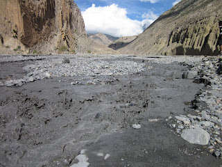
 At that point, pine trees start to cover the sides of the hills. Shortly thereafter, the Kali Gandaki River emerges from a wide valley as a braided river, which occur under rare conditions, including where there is a large amount of sediment and large variations in water flow. They are most common in areas where glaciers continue to grind down the mountains, such as Alaska, Canada and the Himalayas.


Along the trail we continued to meet interesting people including this sheepherder who was headed up into the mountains with four months of supplies.
 The forehead method of carrying loads is common in Nepal and from all signs quite effective. He estimated the weight of his pack at 42 kilos (92 pounds). I also began to notice that the Himalayan ecosystem was remarkably condensed. Within very short walking distances the scenery changed from rice terraces, to corn and wheat fields and then to pine forests. That evening we stopped at Larjung. We had dinner with this 82 year old man whose family ran the guest house.
 He was happy to demonstrate for me the traditional Nepali way of eating dahl bhat (and actually most foods) which was with the right hand. Dahl bhat is a flavorful dish of rice and a light lentil soup with a few vegetables and sauces on the side and is a staple in Nepal. Many people eat it for every meal. (“Dahl bhat power, 24 hours” is a phrase sometimes thrown out to non-Nepalis.) It is a little startling to see for the first time. Besides the messy hand to mouth action, Nepalis eat fast; no time for lollygagging or polite conversation, people after my own heart.


It does take a river of some force to tear down the Himalayas and the Kali Gandaki was doing its best, winding its way through the constantly changing channels on the wide stone-covered valley floor. At this point the valley opened up dramatically and we were met with tall green mountains and waterfalls which seemed to emerge from the tops of the mountains. This brought more suspension bridges and stream crossings.

At times it reminded me of a Bierstadt painting.

Along the trail we continued to meet interesting people including this sheepherder who was headed up into the mountains with four months of supplies.


Wednesday, June 22nd. Larjung (2,550 meters - 8,466 feet) to Kagbeni (2,809 meters – 9,215 feet)
As we left the guest house in the morning we caught our first good views of Dhaulagiri, the seventh highest mountain on Earth.

We were walking beneath this 8,167 meter (26,795 foot) mountain during much of the previous day but it failed to make even one appearance. We had nice views for about 10 minutes before the clouds locked it away from site.

 |
| We frequently found these mantra-inscribed stones stacked into even larger stone monuments during our trek. Upon finding them we added our own stones to the growing piles. |


We made the mistake of telling one woman (not the lady shown above) on a small side street that we would look at her Tibetan trinkets. Within two minutes, four others showed up. Within five minutes there were 20 people with blankets spread on the ground full of necklaces, rings and assorted knick-knacks. We literally ran out of the village. “Slowly looking, no problem”, as one of the vendors kept repeating to me, became one of our themes (e.g., "slowly walking, no problem", "slowly eating, no problem."). Having witnessed people appear out of thin air, it’s quite easy for me to believe the story of the multiplying fish from the Bible. Next was the nice village of Marpha which produces many of Nepal’s local-grown apples. If you can make it from an apple, they sold it.


We ate lunch at Jomsom, the largest town along the trail and the one place that has a landing strip. Jomsom is not particularly attractive so we quickly continued hiking. At this point the trail became REALLY dry and hot.


The Tibetan influence in the region is pronounced with a large Stupa in the center of town, a monastery, and prayer flags and prayer wheels throughout the village. The town was overrun with adorable (and I mean, REALLY adorable) baby calves, sheep and goats.


Ama insisted that the following night we would have a “big party”, “big disco”. It was another great evening.
Thursday, June 23nd. Kagbeni (2,809 meters – 9,215 feet) to Muktinath (3,780 meters – 12,401 feet).
We began our day with another quick walk around town before we finally left Kagbeni behind.


Although this would be one of the shortest hikes of our trek, we did have some climbing over some very dry terrain.
 |
| Some mountain bikers and their porters. One of the bikers was so challenged by the hills that he let one of his porters ride his bike while the biker walked behind. |
However, as we approached the town of Muktinath, we passed several alpine meadows where springs made it possible for some wildflowers to bloom.


We arrived by the early afternoon. After a brief rest, we continued our hike a little farther to the Hindu temple on the hill. The temple is one of the most ancient Hindu temples of the God Vishnu. Surrounding the temple are 108 fountains from which flow ice (probably glacier) cold water.

To wash oneself in the fountains is to ensure good luck and prosperity. Some people merely collect water from the fountains, others pass their head under the fountains and still others strip to their skivvies and run the distance. Nirmal and I opted for a head dousing. As it was, I had to stop four times because the cold water produced a splitting headache.

As with many Hindu temples, the Muktinath temple grounds have bells hanging everywhere. We rang them by the handfuls as we walked the perimeter of the temple. The site is also home to some Buddhist monuments and prayer wheels, as well as an “eternal flame” which emerges from under one of the small temples on site. Having never seen a naturally occurring eternal flame, I was impressed.
 |
| View of the front gate from inside the complex. |
 |
| Buddhist pagodas inside the temple complex. |
We also ran into some Indian holy men (we had passed them occasionaly on the trail and they always struck me as looking like wild-eyed hobos, to steal a phrase from a movie), one of whom implored me in English, “Give me your country, one Rupee”. We took that to mean that he wanted one of whatever my country used for currency, a rather good deal for him since one Nepali Rupee is worth about US$.14 whereas US$1 is equal to about 70 Nepali Rupees. That phrase became our catch phrase for anyone who was being just a little too clever.
 |
We spent a relaxing day in the village with the people who ran the guest house. They put us to work grinding peppers and babysitting. We almost had a gig milking cows the next morning but I slept in a little too late.


Friday, June 24th. Muktinath (3,780 meters – 12,401 feet) to Tukuche (2,590 meters – 8,497 feet)
We started the day with one more trip to the temple where we filled a water bottle from the fountains for Nirmal’s mother. The weather was clear, the sky blue and the mountains white. From Muktinath we had great views of the Muktinath range (5,467 meters - 17,936 feet).

Despite the good conditions, the trip back to Jomsom was a long, hard walk over sand and stones, this time with a constant wind blowing into our faces. We hiked and hiked until the dry climate turned again to forests of pine and cedar. From Jomsom, we also had nice views of the Nilgiri range (7,061 meters - 23,166 feet).


That night we made it to Tukuche where I actually had a hot shower. All of the guest houses advertise hot showers, but few actually deliver.
I think this was the first night I had blisters on my feet.
 |
| The nice "waiter" at the guest house. |
Saturday, June 25th. Tukuche (2,590 meters - 8497 feet) to Tatopani (1,190 meters - 3,904 feet)
Another long walk with some nice weather … and really sore feet. In Kalapani, we stopped on the road side to talk to a woman about the racshi she was distilling (they say it’s homemade wine, but it seems more like moonshine, in this case made from millet) and we ended up having breakfast on her rock fence on goat-skin mats.

Along the trek we were periodically approached by kids asking for “sweets”, or in one case, a “skupen” (school pen). I brought some lollypops and other treats with me for that purpose. By now, the only sweets I had left to offer were red Twizzlers, which although they taste great to me, they weren’t something that Nirmal thought anyone (even curious kids) would like. In Kalapani, we found out. I marketed the Twizzlers as a nifty, edible straw. These boys cracked me up as they tried to figure it out. In the end, I think they got mixed reviews.


We soaked in the hot pools that evening with the locals until it started to rain. That night we had a terrific rainstorm (again magnified by the tin roof of the guest house) and all I could think of was how close we were to that scary (and undoubtedly rising) river.

Sunday, June 26th. Tatopani (1,190 meters - 3,904 feet) to Ghorepani (2,860 meters – 9,383 feet)
Today would be another all uphill day. I was dreading this hike since the previous Monday when we had walked this section going downhill. Mid morning we stopped for a breakfast of eggs and milk, straight from the cow.
 This stretch of the trail is back into the green mountains with rice terraces. We had beautiful valley views, minus the really big mountains. Along the way we passed through a village wedding where we saw two goats who probably didn’t know that they were going to be the evening meal.


It started to rain as we approached Ghorepani so we were wet and a little cold by the time we arrived. I also found and pulled off my first leech. I haven’t been anywhere where leeches are a problem, but I was to find out that this is the season for leeches in the Annapurna region. Fortunately, the guest house had warm showers. It was a fun night in the practically abandoned village, playing snooker ball, trying to stay warm by the fire, having good food and sleeping in a nice room with a big quilt. It rained hard all night which left me hoping that the next morning would be clear for the famous mountain views from Poon Hill.
Monday, June 27th. Ghorepani (2,860 meters- 9,383 feet) to Poon Hill (3,193 meters - 10,475 feet) to Ghandruk (1,940 meters - 6,364 feet)
Just like Ralphie on Christmas day, I woke up the next morning and threw open the curtains to see snow, not on the ground, but on the mountains. We could actually see the Annapurna Range!

After a fast breakfast we did a quick hike up to Poon Hill for the panorama. Although the clouds didn’t stay away long, we did get a chance to see most of the big peaks, including previously mentioned Dhaulagiri, Machhapuchhapuri, and Nilgiri and also Annapurna I (10th highest in the world at 8,091 meters – 26,545 feet) and Annapurna South (7,219 meters – 23,684 feet). Success!


After descending back down to Ghorepani, we began our hike to Ghandruk. We were warned that the leeches were especially bad on this portion of the trek. By the end of the day, I had pulled at least 20 off of my clothes and boots, only two of which managed to attach themselves to my ankles. Much of the hike was in fog and over the tops of some mountains, although they weren’t overly steep. We did pass through some beautiful Rhododendron forests full of ferns, flowers and other plants and crossed a lot of small streams.


Tuesday, June 28th. Ghandruk (1,940 meters – 6,364 feet) to Dhampus (1,650 meters - 5,413 feet ).
For a day with very little net elevation change, we sure had a lot of elevation changes. The first part of the day was spent dropping down to the valley floor and then climbing up and over the other side. On the way down, two young boys approached us and asked for medicine.
 One of them showed me his hand which he had cut while working in the grass. I was happy that I had a first aid kit so I patched him up. Not wanting to be left out, his younger brother showed me some older scrapes on his hands and feet that also needed to have some band aids placed on them. This day’s trek continued into the wet and foggy mountains.
This sometimes brought pleasant views and, unfortunately, more leeches. By the end of the day, I counted at least 40 that had attached themselves to my body, mostly around my ankles.
 I can’t imagine what it would have been like had we been traveling off of a trail. Periodically, we would stop to check for leeches (or you would feel the bite) and we would pick them off. We passed several cows on the trail that had many grossly engorged leeches on them. One of the cows let us clean them off (it seemed to know we were trying to help), but the other was a little too nervous. I felt quite sad about it when we finally gave up and continued our hike.

 It started raining as we approached Dhampus. That night, in celebration of our last night on the trek, we had popcorn and french fries at the guest house, in addition to the standard fare. It was all good.

 |
| Highest spot of the day at the Lucky View Restaurant. |


 |
| A slightly stoned-looking basket maker. These baskets are STRONG. I've seen them loaded to the brim with big stones for construction. |

Wednesday, June 29th. Dhampus (1,650 meters - 5,413 feet) to Pokhara.
At 7:15 we left the guesthouse for the last few hours on the trail. From here the trail is increasingly inhabited.


At Phedi, we caught a crowded local bus back into town and in the blink of an eye, the trek was over.

The rest of the day was spent visiting the awesome Indian barbers for a straight-razor shave (they actually do everything from manicures, pedicures, dye jobs, shaving, head massages, full body massages and even waxings … it makes you think U.S. barbers aren’t trying hard enough), getting a massage (not from an Indian barber), and relaxing. I was exhausted and I felt like I had the stuffing beaten out of me. That afternoon, I met Nirmal’s mother and brothers.


As for my guide, I have no explanation for the bond we shared. It’s hard to imagine two people from more different backgrounds. Nevertheless, for 11 days, I had the opportunity to hike with a friend, and it made all the difference.

I had traveled to Nepal to find inspiring mountains and scenery. While I saw plenty of that (despite the clouds and rain) what I really found was a love for its people who stand out as some of the most endearing I have ever encountered.
As Nirmal accompanied me in the cab back to my hotel, the taxi driver said he needed to pull over for some gas. He returned with a large metal can which was placed in the front seat. I noticed it was capped with an old rag. The driver didn’t seem to worry as he puffed away on his cigarette with us bouncing along the bad roads, a full gas can sloshing only three feet from the red glow between his lips. I looked at Nirmal and with my wide eyes communicated, “Has this guy lost his mind?!” Nirmal took my hint and joked with the guy until he threw the butt out of the window. This was Nepal, a crazy, wonderful place where almost everything is a challenge, where nothing is quite what you anticipate and where unbearable beauty lies around every bend.
